

Skip to content

Explore Earth

Every idea in this book lives somewhere real. Drag to move, scroll or pinch to zoom, and open a numbered pin to see why that spot matters, with links into the chapters. 44 places so far.

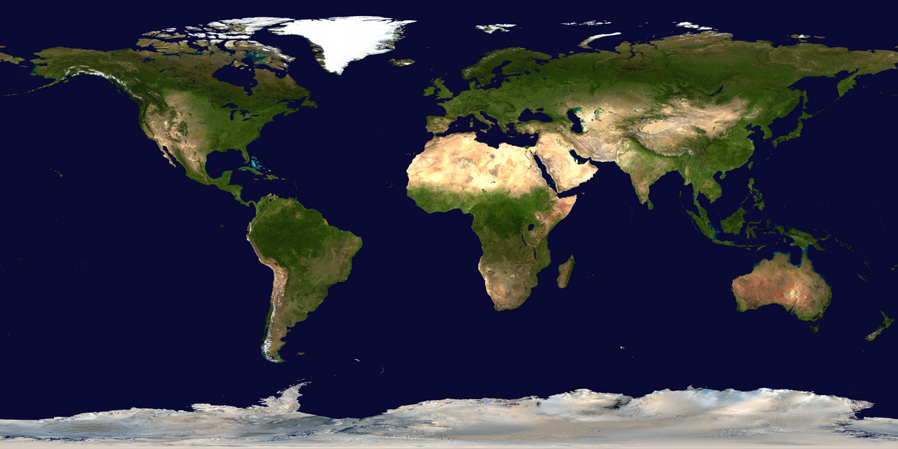
Satellite view of Earth's surface in true color, equirectangular projection.

Drag to move · scroll to zoom · tap a pin

Numbered pin: a place in this bookCircle: this week's quake, sized by magnitudePill: live weather stationAmber: 2011 Tōhoku replay

Base image: NASA Blue Marble (public domain). Pin positions are approximate. Live layers use the USGS and the National Weather Service. The dashed lines are the equator, the tropics and the polar circles.

All 44 locations

The same pins as a reading list, grouped by unit.

Unit 1 · Measurement

1

BIPM, Sèvres, France

48.8° N, 2.2° E · Where units live

The International Bureau of Weights and Measures keeps the world's measurement system in agreement. The platinum cylinder stored here defined the kilogram until 2019, when the unit was redefined using constants of nature.

Measurement in science

Unit 2 · Mapping

2

Mitad del Mundo, Ecuador

0.0°, 78.5° W · The equator

A monument marks where the equator crosses Ecuador, at 0° latitude. Here days and nights stay close to 12 hours all year, and Polaris sits on the horizon.

Latitude and longitude

3

Pleasantville, New York

41.1° N, 73.8° W · Home base

Home of the Panthers, at about 41° N. Stand outside on a clear night and Polaris sits about 41° above the northern horizon, because Polaris altitude equals your latitude.

Locating points on Earth

4

Royal Observatory, Greenwich

51.5° N, 0.0° · Prime meridian

The 0° longitude line runs through this observatory near London. Every longitude on Earth is measured east or west from here, and each hour of sun-time difference equals 15° of longitude.

Longitude and time

Unit 3 · Tectonics

5

Challenger Deep, Mariana Trench

11.4° N, 142.6° E · Deepest point

The deepest known spot in the ocean, nearly 11,000 meters down. It sits in a trench where the fast-moving Pacific Plate subducts beneath the Mariana Plate.

Convergent boundaries

6

Kīlauea and Mauna Loa, Hawaii

19.4° N, 155.3° W · Hot spot volcanoes

The Hawaiian islands sit above a mantle hot spot. Runny, low-silica basalt builds broad shield volcanoes, and the island chain ages toward the northwest, recording the Pacific Plate's motion.

Hot spots

7

Mount Everest, Nepal and China

28.0° N, 86.9° E · Collision zone

Earth's highest peak, 8,849 meters, raised by the slow collision of India with Eurasia. The summit rock is marine limestone: this mountaintop was once a sea floor.

When continents collide

8

Mount St. Helens, Washington

46.2° N, 122.2° W · 1980 eruption

This Cascade composite volcano exploded on May 18, 1980, after thick, gas-charged magma sealed itself under pressure. It is the textbook example of an explosive, subduction-fed eruption.

Why some eruptions explode

9

Mount Tambora, Indonesia

8.3° S, 118.0° E · Year without a summer

Tambora's 1815 eruption was the largest in recorded history. Its ash and gas dimmed sunlight worldwide, and 1816 became the year without a summer, with June snow in New England.

Volcanic hazards

10

Mount Vesuvius, Italy

40.8° N, 14.4° E · Pompeii's volcano

This composite volcano buried the Roman cities of Pompeii and Herculaneum in ash in 79 AD. It is fed by subduction and still watched closely, with the city of Naples at its feet.

Volcano shapes

11

San Andreas Fault, California

35.1° N, 119.7° W · Transform boundary

The Pacific Plate slides past the North American Plate along this famous transform fault. The plates grind, stick, and lurch, which is why California lives with earthquakes.

Transform boundaries

12

Thingvellir, Iceland

64.3° N, 21.1° W · Divergent boundary

Iceland is one of the few places where the Mid-Atlantic Ridge rises above the sea. Here the North American and Eurasian plates pull apart a few centimeters per year, and you can walk in the rift between them.

Divergent boundaries

13

Tōhoku coast, Japan

38.3° N, 142.4° E · 2011 megaquake

In March 2011, the sea floor east of Japan lurched in a magnitude 9.0 subduction-zone earthquake, one of the largest ever recorded. The quake and the tsunami it launched reshaped how the world prepares for both.

Earthquake magnitude

14

Valdivia, Chile

39.8° S, 73.2° W · Largest quake recorded

The 1960 Valdivia earthquake reached magnitude 9.5, the largest ever measured. Its tsunami crossed the entire Pacific, reaching Hawaii and Japan.

The magnitude scale

15

Yellowstone, Wyoming

44.4° N, 110.6° W · Continental hot spot

A hot spot burning beneath the North American continent powers Yellowstone's geysers and hot springs. The park sits inside a caldera left by an enormous ancient eruption.

Hot spots under continents

Unit 4 · Rocks and minerals

16

Giant's Causeway, Northern Ireland

55.2° N, 6.5° W · Columnar basalt

About 60 million years ago, thick basalt lava cooled slowly here and cracked into tens of thousands of hexagonal columns. It is extrusive igneous rock showing off its geometry.

Igneous rocks

17

Herkimer County, New York

43.0° N, 75.0° W · Herkimer diamonds

Not diamonds at all, but quartz crystals with natural points on both ends, found in cavities in ancient dolostone. They are a New York mineral-collecting classic.

Minerals worth knowing

18

The Palisades, New York and New Jersey

41.0° N, 73.9° W · A giant sill

The dark cliffs across the Hudson from Westchester are the edge of a thick sheet of intrusive igneous rock. Magma squeezed between sedimentary layers as Pangaea began to rip apart.

New York's rocks

19

White Cliffs of Dover, England

51.1° N, 1.4° E · A wall of plankton

These chalk cliffs are soft limestone built from the shells of microscopic sea life that rained onto a Cretaceous sea floor. They are an organic sedimentary rock you can see from France.

Sedimentary rocks

Unit 5 · Surface processes

20

Finger Lakes, New York

42.7° N, 76.9° W · Glacial valleys

Eleven long, narrow lakes fill valleys that ice sheets deepened and dammed. Their parallel north-south shapes are the fingerprints of flowing ice.

What ice leaves behind

21

Long Island, New York

40.8° N, 73.1° W · Built by glaciers

Long Island's spine is a pair of terminal moraines dumped by the last ice sheet, with a sandy outwash plain to the south. The whole island is a glacial deposit.

Glaciers

22

Mississippi River Delta, Louisiana

29.2° N, 89.3° W · Deposition

Where the Mississippi meets the Gulf, the water slows and drops its sediment load, building land outward. Slowing water deposits the largest particles first, sorting as it goes.

Deposition

23

Niagara Falls, New York

43.1° N, 79.1° W · Erosion at work

The falls pour over a hard dolostone cap above softer layers. Undercutting has walked the falls about 11 kilometers upstream since the last ice age.

Agents of erosion

Unit 6 · Landscapes

24

Adirondack Mountains, New York

44.1° N, 73.9° W · Ancient dome

A circular dome of highlands exposing New York's oldest rocks, metamorphic gneiss about a billion years old. Also the site of a success story: lakes acidified by acid rain have been recovering since emissions rules took hold.

New York landscapesAcid rain and recovery

25

Catskill Mountains, New York

42.1° N, 74.3° W · A plateau in disguise

The Catskills look like mountains but sit on flat-lying, undistorted sedimentary bedrock. High elevation plus horizontal strata makes them a plateau, a favorite exam trap.

Landscape types

Unit 7 · Geologic history

26

Burgess Shale, Canada

51.4° N, 116.5° W · Cambrian time capsule

High in the Canadian Rockies, these shale layers preserve soft-bodied sea creatures from about 508 million years ago. They give science its clearest window on early animal life.

Correlation and fossils

27

Grand Canyon, Arizona

36.1° N, 112.1° W · Superposition on display

The Colorado River has cut through a stack of nearly two billion years of rock. Oldest layers at the bottom, youngest at the top, with unconformities marking missing chapters.

Relative dating

28

Siccar Point, Scotland

55.9° N, 2.3° W · Hutton's unconformity

In 1788 James Hutton saw tilted rock layers buried under flat-lying ones here and understood the immensity of geologic time. It is the most famous unconformity in science.

Unconformities

Unit 8 · Meteorology

29

Mount Washington, New Hampshire

44.3° N, 71.3° W · Wildest weather

Storm tracks converge on this modest peak, giving it famously violent conditions. In 1934 its observatory measured a 231 mile per hour wind, long the fastest ever recorded at a staffed station.

Wind

30

Tornado Alley, central United States

35.5° N, 97.5° W · Storm country

Cold, dry air from Canada meets warm, humid Gulf air over the plains, breeding strong fronts, thunderstorms, and more tornadoes than anywhere else on Earth.

Severe storms

Unit 9 · Climate

31

Amazon Basin, Brazil

3.1° S, 60.0° W · The wet belt

Moist air rising along the equator feeds daily rain and the largest rainforest on Earth. It is the rainy half of the same circulation that dries the Sahara.

The global pattern

32

Atacama Desert, Chile

24.5° S, 69.3° W · Driest desert

The driest non-polar place on Earth. The Andes block moist air from the east, a cold offshore current starves storms from the west, and some spots go years without rain.

Mountains and rain shadows

33

Gulf Stream, off Cape Hatteras

35.2° N, 74.0° W · A river of warm water

This warm current carries tropical Atlantic heat north past our coast and on toward Europe. It is a big reason northwestern Europe stays far milder than its latitude suggests.

Ocean currents

34

Mount Kilimanjaro, Tanzania

3.1° S, 37.4° E · Snow near the equator

A dormant volcano just south of the equator, high enough that ice survives near its 5,895 meter summit. Elevation cools climate about as powerfully as latitude does.

Elevation

35

Sahara Desert, Africa

23.5° N, 13.0° E · The dry belt

The world's largest hot desert sits near 30° N, where the planet's circulation sinks dry air. Notice how it lines up with the Tropic of Cancer on this map.

Latitude and climate

36

Tug Hill Plateau, New York

43.7° N, 75.7° W · Lake-effect champion

Rising just east of Lake Ontario, Tug Hill catches the full force of lake-effect storms. It is one of the snowiest places in the eastern United States, often topping 20 feet in a winter.

Water and lake effect

Unit 10 · Astronomy

37

Bay of Fundy, Canada

45.1° N, 64.8° W · Greatest tides

The shape of this bay funnels and amplifies the twice-daily tides to the largest range on Earth, up to about 16 meters. The moon's gravity does the daily work.

Tides

38

Chicxulub crater, Yucatán, Mexico

21.4° N, 89.5° W · The dinosaur killer

Buried under the Yucatán is the crater of the asteroid strike 66 million years ago that ended the Mesozoic Era. Its layer of debris marks the boundary in rocks worldwide.

ImpactsThe geologic time scale

39

Kennedy Space Center, Florida

28.6° N, 80.7° W · Borrowing Earth's spin

Rockets here launch toward the east to borrow Earth's rotation, which already carries the pad along at about 1,500 kilometers per hour. Lower latitude means a bigger free boost.

Earth's motions

40

Mauna Kea Observatories, Hawaii

19.8° N, 155.5° W · Window on the universe

At 4,200 meters, above much of the atmosphere's water vapor, some of Earth's largest telescopes read light from across the electromagnetic spectrum.

Reading starlight

41

Meteor Crater, Arizona

35.0° N, 111.0° W · Impact scar

About 50,000 years ago an iron asteroid fragment blasted this bowl, 1.2 kilometers across. It is the best-preserved impact crater on Earth.

Asteroids, comets, and meteors

Unit 11 · Human impact

42

Great Barrier Reef, Australia

18.2° S, 147.0° E · Living structure

The largest structure built by living things, visible from orbit. Warming ocean water stresses its corals, making the reef a sensitive gauge of climate change.

Human impacts

43

Mauna Loa Observatory, Hawaii

19.5° N, 155.6° W · The Keeling curve

Since 1958, instruments here have measured atmospheric carbon dioxide climbing year after year. This record, the Keeling curve, is the backbone of modern climate evidence.

Evidence of change

44

Vostok Station, Antarctica

78.5° S, 106.8° E · Reading ancient air

Ice cores drilled here preserve bubbles of ancient atmosphere. They let scientists compare carbon dioxide and temperature across hundreds of thousands of years.

Ice cores

Donate

I make these tools in my spare time and keep them free for classrooms. If they've helped you, any gift goes toward the costs of running them, and it truly means a lot.

Loading secure payment

Secured by Stripe. No account needed.

Send feedback

An idea, a bug or a question. It comes straight to me.

Your email is only used to reply.